Audited source records
81Unique parcel identifiers.
Four cadastral blocks appear in the file. Its “CROWN” labels need checking against current title and parcel history. 1
Land / homes / public services
A land record is a starting point. The public goal is a secure home, a safe route and a place people can use. This inquiry connects the two.

01 / The research in a minute
The supplied Morne du Don workbook gives us identifiers to investigate. The next step is to establish what the land does today, who depends on it and what could work better.
Audited source records
81Four cadastral blocks appear in the file. Its “CROWN” labels need checking against current title and parcel history. 1
Concentration in the file
55This is a share of records. The workbook gives no parcel areas, boundaries or verified current uses. 1
A historical connection
2016One identifier matches an official plan for 34 residential lots. That creates a precise question about what happened next. 2
02 / Follow the record
Workbook audit
Distinct block-and-parcel identifiers
Every row has a block, a parcel number and the labels “CASTRIES” and “CROWN”. Together, the block and parcel number form the key used in this audit. All 81 keys are distinct. 1
There is no information on size, occupation, access, hazards or service capacity. Some identifiers may refer to land that has since been subdivided, transferred or put to another use.
| Cadastral block | Records |
|---|---|
| 1048B | 3 |
| 1048C | 21 |
| 1048D | 2 |
| 1048F | 55 |
| Total | 81 |
The workbook has no header. Row 1 is a valid record, so treating it as column names would undercount the file by one. The audit retained rows 1–81, excluded 919 empty rows and found no repeated or invalid keys. No populated row was discarded.
Distinct keys can still include old parent parcels and later subdivisions. The file provides no current registry verification or capture date. No housing capacity, land area, land value, vacancy rate or parcel suitability is estimated here.
An existing legal route
Section 47 provides for a mapped planning register covering applications, decisions, appeals, notices and completion records. Any person can seek information and copies, subject to the prescribed fee. A targeted extract can connect a parcel to its planning history. The availability and completeness of the records still need testing. 7
A national change to follow
A February 2026 tender sought an electronic Land Registry Information System, record migration, training and support. Follow the award, contract start, record reconciliation and operational acceptance. The tender sets out intended work; it does not establish current delivery. 6
The local service trail
A 2020 Morne du Don–Balata road announcement described drainage and retaining-wall works. A 2025 project tour named Agard Playing Field, Morne du Don retaining walls, the Chase Gardens/Carellie Human Resource Development Centre and Carellie Park. These dated records identify useful follow-up cases; present condition and service performance need checking. 89
The administration’s own diagnosis
A November 2025 government presentation described fragmented workflows, limited integration and outdated technologies in land administration. Treat this as a dated diagnosis. A local case register can help trace survey, valuation, planning, legal and service milestones while the wider system changes. 16
03 / A significant 2026 development
The new Saint Lucia Unplanned Development Regularization Authority Act makes the service question central to the legal design. Its definition of regularization combines infrastructure and services with title through conveyance or lease. 5
Sections 52–53 link completion to subdivision, title transfers, roads, drainage, sewage and utility infrastructure, final inspection and a Gazette declaration. This gives a clear research question: which steps has each programme actually completed?
Section 41 provides for area budgets, timelines and impacts in quarterly reporting. A useful public account should show both legal progress and the services people can use. 5
The Act was published on 30 March 2026. Section 1(2) requires a ministerial Gazette order for commencement. This research did not establish that order or the Authority’s operational status.
Obtain the commencement order, appointments, regulations and any designated-area orders before treating a place as covered. The Gaboo record does not itself establish coverage under the new Act. 5
What this changes in the research
An offer, a payment, a registered transfer and a completed drain each answer a different question. The 2025 Crown Lands form records administrative stages and distinguishes purchase, lease and easements for access and utilities. These records can show where a case is moving and where it needs action. 14
Follow legal progress and everyday services together.
A reading guide for the proposed review. The lawful route and required works must be established for each site.
Under section 31 of the Physical Planning and Development Act, a development permission can require land reserved for public recreation or open space. Its conditions involve compensation, a Gazette vesting order and Crown registration. Where vesting is required, registration must precede the completion certificate. 15
For a proposed community space, trace the planning condition, land rights, any required compensation and vesting, the manager and maintenance funds. These steps must be established for the particular site. The 2026 Act also protects specified public purposes through its designation provisions; the exact boundaries and lawful route matter. 5
04 / An interactive decision guide
The same land question can lead to different work. Select a purpose to see the evidence needed, the choices to weigh and the result to follow.
The purpose / Resident tenure
Start with the people who live there. Establish their claims, the current title and the legal route before making an offer.
A title or lease can improve security. Fees, disputed claims or unaffordable terms can exclude the people the programme aims to help.
Compare eligible forms of tenure case by case. Keep access routes and public-service space protected before a permanent transfer.
Arrange a confidential claims and title review, with plain-language notices, help to respond and an appeal route.
Track resolved claims, secure agreements and household costs. Include unresolved cases and reasons for delay.
The purpose / Drainage & access
A small strip can matter to many homes. Its value depends on how it connects to the wider road and drainage system.
A new drain can reduce flooding at one point while sending more water elsewhere. A road can improve access while disturbing homes or slopes.
Compare an easement, a reserved corridor and public ownership. Secure the full connection before committing to works.
Walk the route with residents and engineers, then record the full path of water and access rights.
Track route interruptions, access to essential services, drainage failures and completed maintenance.
The purpose / Community space
Ask who would use it, when they could get there and who would keep it open. Good design starts with the local need.
A shared space can support play, care and local activity. It also takes land, staffing and money that may serve another pressing need.
A lawful short-term use may help test demand. Protect future access and public use in any longer agreement.
Test the proposed use with residents and service providers. Compare a reversible trial with a permanent building.
Track access, hours open, range of users, condition, maintenance and resident feedback.
The purpose / Housing development
Count the full cost of a working home: land, construction, transport, water, drainage, electricity and upkeep.
More homes can meet a real need. Poor access, unstable slopes or expensive services can make a low land price costly for households and the state.
Compare sale, lease and retention against the public purpose. Test the costs and enforceable conditions before choosing a route.
Commission a site and service assessment, then compare feasible housing forms and household costs.
Track safely occupied homes, total household costs, reliable services and delivery against agreed terms.
SLPA decision guide. Each purpose needs verified site evidence, lawful approvals and resident engagement before a parcel’s suitability can be established.
05 / Applying the SLPA frameworks
Michel’s frameworks work together: IIR diagnoses current functions; RIPPLE-4 traces effects; IIR tests readiness across the alternatives; Sovereign Option Theory guides choice and timing.
IIR / Institutional Intervention Readiness
Identify present functions, harms and rights. Compare feasible alternatives and show how essential access, drainage, services and resident security will continue through a change. 10
Who provides each essential service before, during and after the work?
Read the IIR framework →RIPPLE-4 / Follow the consequences
Trace direct effects, people’s responses, wider system effects and the conditions future residents inherit. Check each causal link and use the findings to change the design. 11
Could a change in tenure or access shift rents, service demands or costs elsewhere?
Read the RIPPLE-4 framework →SOT / Sovereign Option Theory
Hold the public purpose steady while increasing commitment as evidence and capacity improve. Preserve usable choices for households and the state, and count the harm of waiting. 12
What can we learn before a decision becomes costly to reverse?
Read Sovereign Option Theory →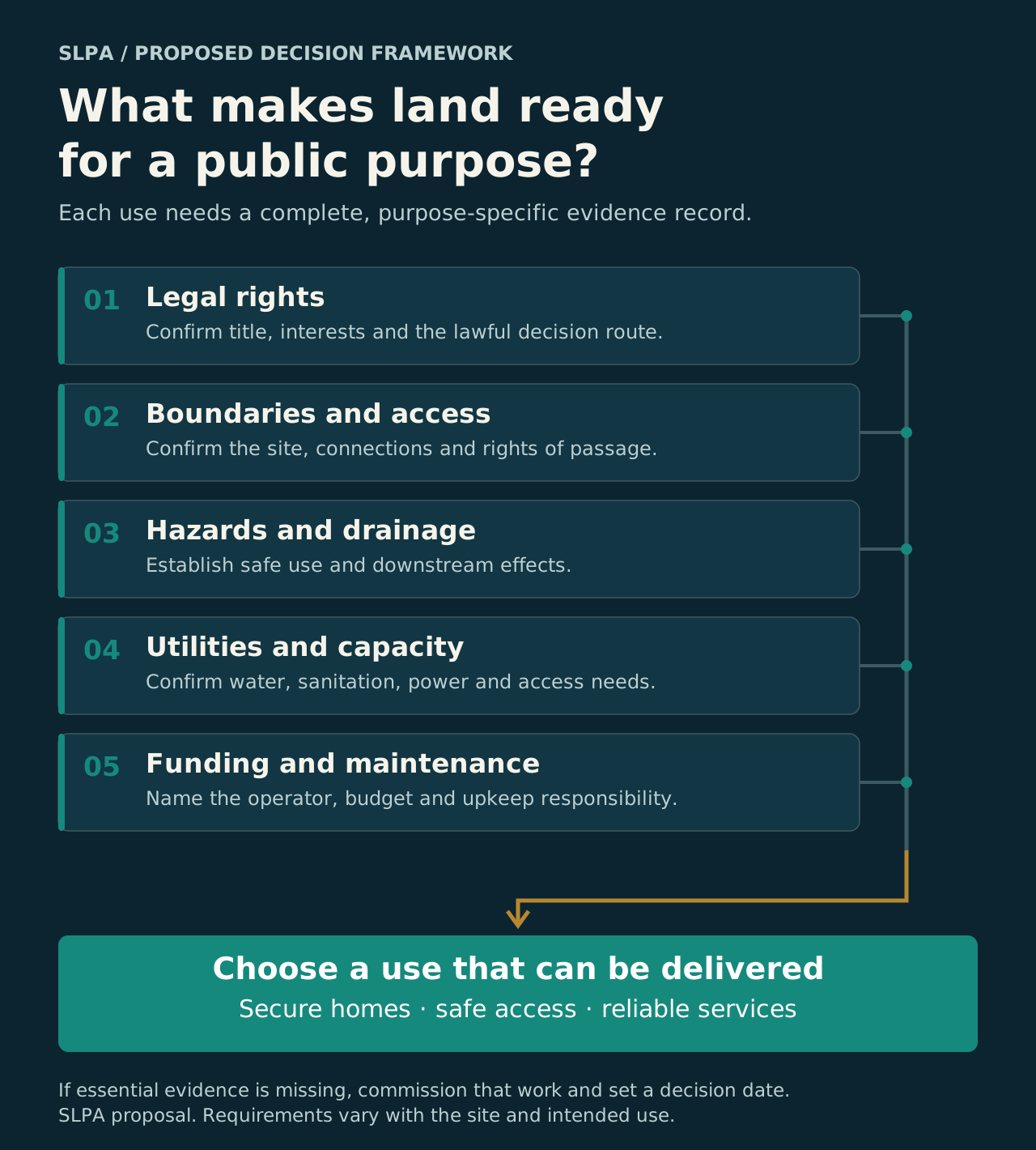
A decision people can check
A sale may improve household security. A lease may keep useful public control. A long, rigid lease can also leave little room to adapt. Keeping land in public ownership still requires attention to current harms and unmet needs.
The choice should turn on affected people, legal rights, whole-life costs, safe service delivery and future options. SOT supports that comparison; it does not prescribe one tenure instrument for every site. 1210
Learning should arrive while correction remains possible. Establish essential service coverage and a funded transition before a disruptive step. Urgent protective repairs can proceed through their proper authority while the larger decision is assessed.
These applications of Michel’s conceptual frameworks depend on local evidence. They provide a structured way to investigate and compare choices.
1. Direct effects: Who receives a more secure right, a new payment obligation, access or a change in use? Establish starting rights and affected people.
2. Participant responses: How might households, landlords, lenders or businesses respond? Investigate investment, rent, sale, occupation and travel decisions.
3. System effects: Could those responses change demand for water, roads, drainage, transport or local services? Check capacity and effects that cross site boundaries.
4. Inherited conditions: What recurring costs, land choices, liabilities or patterns of exclusion might persist? Compare options over the same horizon and identify evidence that could change the decision. 11
These are questions to test, rather than measured effects in Morne du Don. RIPPLE-4 expands to Recursive Impact Pathways, Politics, Leverage, and Exposure. No composite risk or readiness score is assigned here.
06 / A practical first pass
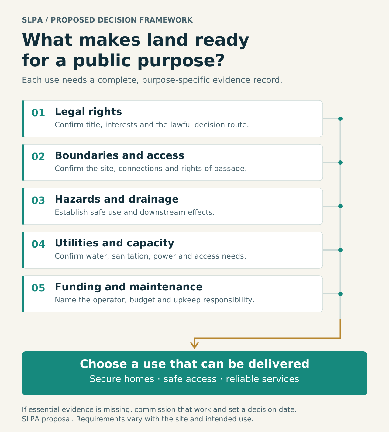
Start with the Gaboo historical record and a small, defined set of access or public-space questions. The first commitment is to evidence, resident needs and a reasoned choice.
Name a responsible lead and participating offices. Confirm current authority and any commencement or designation orders. Request the current register, survey and history for 1048C 180; trace successor lots. Check constituency boundaries and planning records. Establish a confidential route for resident claims.
Output: A dated case register with sources, gaps, responsible offices and response dates.
Walk the area with residents and relevant professionals. Examine access, drainage, hazards, utilities and current use. Compare lawful options, their full costs, household impacts and service needs. Record urgent protective work separately.
Output: An options note with checked evidence, maintenance needs and unresolved questions.
The competent authority should state what can proceed, what must change and what needs more evidence. Identify approvals, delivery owners, funding and service conditions before a larger commitment. Publish aggregate progress and give residents a route to challenge errors.
Output: A reasoned decision with a funded work plan or a dated plan to close the remaining gaps.
Keep distinct counts for records reconciled, claims resolved, offers accepted, transfers registered, service works completed and facilities open. Record time spent at each stage and why cases remain unresolved.
The proposed pilot has no verified budget in this research. Scope, staff time, fees and professional work must be costed before adoption. Ninety days is an evidence and decision window; complex claims and capital works may require longer.
07 / Evidence, methods and further work
This first pass joins an audited source file, a specific historical project, current legal research and a practical framework for deciding what to do next.
Research paper / 20 October 2026
Read the full analysis, source audit and proposed evidence programme. The four block totals are also available as a CSV for checking the chart.
Source audit. The preserved XLSX was read directly, retaining sheet and row references. The audit checked populated rows, key formats and duplicates. Counts and charts use that executed audit. File upload dates remain separate from the unknown date of the underlying records.
Geography. Supplied constituency and district maps were inspected alongside official electoral descriptions. They contain no crosswalk to the workbook’s parcels. A current cadastral overlay is required. The hero photograph shows Vigie as community context.
Legal research. Relevant provisions in the 2023 revised laws were checked alongside the official 2024–2026 legislation indexes. The official 2026 regularization Act was read. Commencement and operational status remain open questions. The research establishes no individual entitlement or parcel-specific approval.
Policy analysis. The 90-day programme and explorer are SLPA proposals. They apply IIR, RIPPLE-4 and SOT to choices that need local evidence. Site suitability, housing yield, numerical readiness scores and unverified budgets are not estimated.
Next evidence. Obtain current title and parcel history, geometry, planning and completion records, resident and use evidence, professional hazard and service assessments, whole-life costs and named operators. Publish aggregated outcomes and protect personal claims and household records.
Source / S1
Supplied working file, access may require permission; executed audit, 20 October 2026, inventory date unspecified.
Source / S5
Published 30 March 2026; sections 1, 2, 41, 43–46 and 52. Commencement/local designation unverified.
Source / S6
LC-DPS-520514-GO-RFP,issued 17 February and published 18 February 2026.
Source / S7
Attorney General’s 2023 consolidated text; verify subsequent changes for implementation.
Source / S8
24 June 2020, dated announcement of road, drainage and retaining-wall works.
Source / S9
10 April 2025, Agard field, Morne du Don retaining walls, Carellie/Chase Gardens facilities. Current condition unverified.
Source / S13
Government, 20 May 2016. Reports offers; completed payments and registered transfers require follow-up.
Source / S14
Government form, 2025 filename. Distinguishes purchase, lease and easements and records several processing stages.
Source / S15
Attorney General’s 2023 consolidation. Public recreation and open-space reservation, compensation, vesting and registration provisions.
Source / S16
Government presentation by Marcathian Alexander, 7 November 2025. Dated diagnosis of rights, planning, technology and workflow issues.